Saltar al contenido principalSaltar al pie de página

AIR TECHNOLOGY FOR MORE SUSTAINABLE LAND MANAGEMENT

DRONES, SENSORS AND GEOSPATIAL ANALYSIS FOR AGRICULTURAL, ENVIRONMENTAL AND TECHNICAL PROJECTS

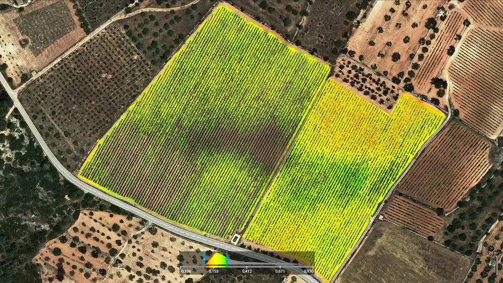
Drones for agriculture and the environment: at Beesual Drone, we combine aerial technology, advanced sensors, and geospatial analysis to provide accurate, actionable information for agricultural, environmental, and technical projects. We turn imagery into maps, models, and data ready to integrate into CAD, GIS, or BIM workflows. Our solutions help optimize the use of natural resources, improve territorial planning, and support more sustainable decisions based on clear evidence.

Challenges we address

We apply aerial technology where it’s needed most

How we work

Clear and professional methodology
Beesual-ComoTrabajamos-beesual-drone

We define objectives together with the client

We capture data with RTK, multispectral, and thermal drones.


We process the data using GIS, CAD, and photogrammetry software

We deliver interpretable results, ready for planning, construction, or technical decision-making

Note: All projects include visualizations tailored to the client’s profile: georeferenced maps, graphic reports, or models compatible with QGIS, AutoCAD, and Revit.

Who trust us

We support professionals, entities, and organizations
Agricultural producers and technical advisors
Architecture firms and engineering offices
Environmental NGOs and universities
Public administrations and land managers

Vision and differentiation

We don’t just fly: we interpret, solve, and support

Diagnosis from aerial imagery with technical precision

Professional processing with Pix4D, Agisoft, and QGIS


Deliverables compatible with AutoCAD, Revit, and BIM platforms

European certifications (AESA/EASA) and international experience


Clear communication for technicians, project managers, and public administrators

Integration of sustainability criteria from planning to delivery

We transform geospatial data into impactful technical decisions.

Need fast results?

Write to us and we’ll plan your next technical flight.
Get 10% off your first project by mentioning this website.
Fill out this field
Fill out this field
Please enter a valid email address.
Fill out this field
You need to agree with the terms to proceed

Drone technology in your inbox

Real-world applications, analysis, resources, and services. Subscribe to our newsletter

    Accessibility Toolbar